20200222

Salt Point St Pk, 2/18 - 2/20/20


North from Point Reyes, through Bodega and Jenner, on Hwy 1, you'll eventually reach Salt Point State Park.  Parts of the 63-mile drive are tortuous for rigs like ours, as the narrow road dives in and out of cove inlets, including a number of tight 15-MPH hairpin > turns.  I had the wheel this morning and did okay, but my arms were tired by the time we reached the state park.  No one was at the entry kiosk, so we drove down to the overflow camping at Gerstle Cove where we wanted to park Tergel, hoping it wouldn't be packed.  We lucked out, as you see in the picture below -- the overflow lot was empty.  Suited us to a T.  Later on we toured the campground and it, too, was empty.  The next day we were joined by two other campers, but overflow has plenty of room w/o crowding.  No hookups, of course.

We've been fortunate this week weather-wise, with sunshine galore, no fog or rain; chilly nighttime temps, and warm/ish days.  Kind of unusual for February, but great for us being Out and About!


Tergel sits alone, facing the wide blue Pacific.  Bliss.


On Tuesday, after paying (state parks are getting costly, but we DO have an expansive ocean view), and getting Tergel set where we wanted, we were out the door, on our way to the water. From where Tergel sits, several trails cut through the grass to the water.  A path runs along the cliff, between and over tumbled rock piles, with easy access in many spots to get right down to the water's edge and tide pools.  Oh my, this is such a scenic park! 


Clumps of Calla lily were a bright surprise.


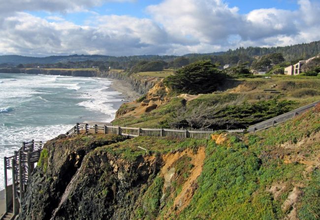
Being able to hop from boulder to rock to shelf helps if you're trying to get to the water.  Just pick the right route!  You can see the tippety-top of Tergel at the red check mark.


Nice perch, Jimmy!
Watching a mountain goat (me) clamber over the rocks.


This type of rock is called tafoni, and it's fascinating.  Enlarge the photo for a closer look at the above sampling (use your back arrow to return here).  Tafoni typically develops in coarse-grained sandstone or coarsely crystalline rock types, often occurring in groups that can riddle a hillside, cliff, or other rock formation.  This natural phenomenon is common to the sandstone near the ocean's edge here at Gerstle Cove.  "An Italian word for cavern, tafoni refers to a honeycomb-type erosion caused by seasonal wetting and drying of the sandstone, weakening it into pits, knobs, ribs and ridges."  Definitely seen at Salt Point (above and below)!


We were entertained by a pair of Northern Harrier hawks, either sitting atop a rock pile or hovering o'er the grassy fields like helicopters, hoping to hear a mouse rustle below. 

 
Gerstle Cove State Marine Reserve allows recreational diving, kayaking, and underwater photography.  With all the bull kelp growing, I'm sure the water would be teeming with life.


Mussels? barnacles?
An ocean full!


While I was looking at that interesting knob at top, I became aware of a white blob on the rocks close to the water, like a fat tube of toothpaste.  Aha, harbor seal resting comfortably (how is that possible on barnacles?), waiting for the tide to come in, which was happening.  I altered my course, so as to not disturb it.  Looks pretty comfy, below, huh?


Oops, she/he heard me and is now awake.  The tide has risen, and high tide can't be far away, so, it slid, like silly putty or syrup spilling onto pancakes, into the water, below.


And, there it sat for a few minutes,
like we do when we first wake up.


The clear, cold water makes peering into tide pools a lot of fun.
So much marine activity to see.


Weirdest configurations ever.  Not always easy to get from place to place, but rock hoping is still a favorite of mine!  I try to be extra careful these days since I'm no longer 30 years old (though I feel like it when I'm scrambling around) ....


We enjoyed a brief orange sunset, but the photo is gone.  The next day (Wednesday) we spotted whales spouting as soon as we were out, which is always exciting!  We decided to walk on the ocean's edge path in the other direction today, to Stump Beach Cove.  What a wonderful time we had, ambling along, over rocks, up and down to the water, watching harbor seals and the incoming waves exploding against the rocky shore and the Harriers stalking mice in the fields.  At the Cove, we spied more seals with only their heads poking above the water, and sea otters stooging around the kelp, and Pelagic Cormorants clinging to nests on the cliffside.  We passed our binocs back and forth as one of us eyed something new.   Super morning!

Black Point Beach

After lunch, we hopped in Smartie so we could explore a few Sonoma County beaches further north.  We stopped at Black Point Beach first, photos above and below lifted from the 'net.  It's a sandy shore of black pebbly sand reached by a steep wooden staircase.  It curves for a quarter mile along the base of sea cliffs.  We walked to the southern end to peer into what seemed to be caves, but the rocks were so slippery, I gave up before reaching the cave.  We saw lots of sea stars and anemones and a couple of saucer-sized crabs.  


We drove further north (into Sea Ranch, an unincorporated community) to Pebble Beach, below (photo also from the 'net), descending another long staircase to the sand.  A family was plying the tide pools (just past low tide), looking at all the Abalone clinging to rocks, more urchins and sea stars and anemones.  Lots of hermit crabs.  Jimmy and I joined the ranks on the slippery rocks to peer into the tide pools.  We found a "vacated" abalone shell and brought it home, which is legal.  It's kind of beat up, but the nacre is so pretty.  Eventually we tired and found our way back to Tergel.  This was the best day!  I took loads of A+ pictures, and when I imported them into the computer, I forgot (good grief) to save them in the computer, and then deleted the pics from the SanDisk (because I was in a hurry).  Apparently these pics are gone forever, which is heartbreaking because I think they were some of the best.  OH WELL.


We left Salt Point on Thursday morning, not hooking together till we got to Bodega due to those hairpin turns, arriving home late afternoon and began the unloading process.  Really, really nice week-plus Out and About in Tergel.  I'm writing this on Saturday, and guess what?  We tried the dinette slide earlier today, and it went out just like it's supposed to and came back in like that, too.  So ... we hit a bad patch on the slide for a week, and now it seems to be fine.  OH WELL!

Life is good and we are grateful. 

20200221

Limantour Spit, Monday 2/17/20


A sunny, half-way warm day enticed us to hit the beach.  Beach time at Point Reyes!  Our choice was Limantour Spit, a long, skinny peninsula, with Drakes Bay on one side and Limantour Estuary (Estero de Limantour) on the other.  Five miles out and back on hard-packed sand along the seashore to the end of the spit.  We walked and walked and walked; didn't take off our shoes ... just enjoyed being in the sun and wind on this beautiful beach.  Very few people were Out and About this morning, but that would change as we neared the path to the car on our return.

The bay is named for Sir Francis Drake, whose round-the-world expedition is said to have stopped here in 1579, though it's not like he etched "I was here" on a rock!

Today is President's Day, the last day in this three-day wkend.  We figured the campground would clear out by afternoon (we were right).  We recorded 39° this morning, but the temp warmed nicely as the day wore on.  


Looks empty above, doesn't it?  And clean ... hardly any rocks or shells and no trash, level and smooth, perfect for walking.


We spotted lots of Surf Scoters in the waves.
They don't use surfboards (haha).


The tide deposited a couple of big ol' jellies on the sand.  They wiggle like a "bowlful of jelly" if you touch them with your foot.  (Don't use your hand, lest they still be able to sting).  Using my shoe as a yardstick, you can gauge the size of this unsightly pile.


No dogs allowed on this end of the beach -- because Snowy Plovers (above) are beginning to nest.  They're a cute li'l small shorebird, about the size of a sparrow, and they don't go to a lot of trouble to make a nest -- usually a shallow scrape or depression in the sand, as you see.  (We saw dogs, and off leash, of course, and against the rules, but who cares, right?  Rules only apply to you.  Grrrr)  I enjoyed seeing these plovers.


Actually we saw quite a variety of interesting "stuff" on Limantour Beach, including this antique hunk of ...?  Jimmy thought it looked like a ship's compressor of sorts, while the ranger at the VC thought it might be part of an engine block from a ship that sank.  Either is plausible.  Quite a number of shipwrecks occurred off Point Reyes in and around Drakes Bay.  One thing is sure ... it ain't going anywhere.  It must weigh tons.


I saw these two Long-billed Curlews away from the water, up on the sand and knew I had a winner of an unusual picture!  By gum, I was able to get closer and they didn't fly.  A young man sitting with several other guys a short distance away saw me clicking away on the shutter and came over.  "You can pet them if you want to," he said.  "They're decoys."  Well, nuts, they LOOK real.  "That's the point!"  He and his team were trapping and banding curlews to find out where they go when they leave the coast.  Hence, decoys to lure some birds in.  Jimmy and I laugh whenever we see this pic.


Here, we're looking toward the estuary where scores of shorebirds are feeding in the wetlands.  We walked to the estuary-side between sand dunes covered with sea oats which separated the bay from the estuary.  The small black thing in the middle of the photo is a good-sized crow, mewing like a cat.


Lots and lots of ducks, mostly Northern Pintails in this photo, are taking advantage of the bountiful estuary.  We didn't walk on this side (it kinda ponked).


Back to the beach.


Then there was this!  Spotted from where Jimmy is standing (red check mark), I trudged through the softer sand to inspect it.  We decided it must be a whale's vertebrae, but when I showed the pic to the ranger, she thought it could be part of a whale's skull.  Either way, this hunk of bone was large.  Migrating whales skirt the continental shelf; gray whales often swim quite close to the Point Reyes shore in winter.


Ah, what a lovely, lovely walk, but our feet were ready for us to sit down!  We retrieved our lunch from the car and parked ourselves on the picnic bench.  Jimmy collected these sand dollar skeletons during our walk -- the only "shells" we saw -- and sorted them by size to display.  He left them on the table for others to admire and perhaps add to their shell collection. 

The parking lot was full.  More and more people with beach towels and blankets and lunches were heading for the water, and many had already set up just off the path.


As we drove away, these two distracted us.  I swear it's the same two that are following us!  Actually a third, smaller one was hiding in the brush, obviously a youth.  Well, maybe they aren't the same pair, but, anyway, they all look alike!

20200219

Made it to Pt Reyes - Sunday 2/16/20


I hope every traveler knows that the best day to drive through any major city is Sunday; no hurrying worker-bees or lunchy-loos to contend with or school buses to avoid.  Just drivers out for a Sunday outing or church folks looking for a diner.  For us, this Sunday was plopped in the middle of a 3-day-weekend, so an above-average amount of drivers littered Hwy 1.  Yup, we drove from Monterey through Half Moon Bay, into San Francisco, over the Golden Gate Bridge to the town of Olema, by Point Reyes Visitor Center.  All on twisty-turny, narrow Hwy 1 which hugs the coastline.  In San Francisco, Hwy 1 became narrow, hilly 19th Street, and slow-moving!  Jimmy drove in the city so I could navigate.  And we did A-OK.


But first, we passed and stopped at Pigeon Point Bluffs overlook, so we could take a picture of this handsome lighthouse.  We didn't try to go in because we're never sure if there's room for Tergel and Smartie together, or if we could turn around.  Made a pretty picture!


Is this a field of mustard?  Rapeseed?
Whatever it is, I love the color!


Jimmy also drove across the bridge so I could take pictures.  Haha, really it's because I hate driving across bridges, especially this one for some reason.  Heck, we've walked across this bridge from one side to the other AND back!  Anyway, I was too busy taking pictures to feel nervous for which I'm grateful.


Overlooking San Francisco Bay and Alcatraz.  Jimmy and I visited the island with my brother, Rus, and SiL, Anne, back in September 2012.  We toured the penitentiary, now a museum, but I tell you true, the four of us were glad to get back on the ferry and return to San Francisco (below).


Eye-catching skyline.


We figured a yacht club must be having a regatta 'cause we saw lots and lots of sailboats on the east side of the bay.  Two or three of them have black sails.

I suppose we must be nuts to travel without a campground reservation on a three-day-weekend, but we figured we'd get a site at Olena Campground.  Too bad our Good Sam card expired last June, and we were unaware of it, so we had to pay full price.  While many sites were taken, plenty were still available; we had no problem.  With a lot of families Out and About this weekend, kids were playing when we arrived, having noisy fun, but the night was quiet.  We slept well.

We wanted to get in a walk/hike after arriving and setting up, but the afternoon was waning -- so we picked a short hike that was the closest to the campground.  Giacomini Wetlands, off Hwy 1, is a restored wetlands habitat, and good for birding.  Goodness, when we got out of the car, a blast of cold north wind hit us in the face and we debated about continuing.  We did, but we never warmed up; we both needed our jackets (which were in Tergel).


The first "wild" animal we spotted was a black cow on the path.


And they were roaming the hillsides....


Next item of interest to me was this large shrub, which had a slightly pleasant fragrance, but I have no idea what it is. 


As you see, the tide was out (of Tomales Bay) where Lagunitas Creek crosses.  We heard geese but saw no birds or other wildlife.  Everything was probably holed up to stay out of the wind! 


Yacht for sale?  A fixer-upper?


Nice to get out after sitting in Tergel for several hours.
We put in a couple of miles.


Returning to Smartie, we encountered Bossie ambling down our trail.  Notice I said "our."  Get off our trail, we told her.  She gave us the stink eye.  She's big, like a-tank-big.  I was going to walk past her, but something in her eyes made me hide behind Jimmy.  She finally mooved and we could go by.


Hmmm, Number 326.  I don't remember what I told her, but she took offense.  As I started past, she made a hostile moove, like she was going to charge into me!  Whoa, Nellie, I said, get back #326, and hid behind Jimmy again.  We scurried by this gal and I realized this is the first time I've ever felt uncomfortable walking in a field with cows.  Guess I should brush up on my sweet-talkin'.

Tomorrow is supposed to be a fine weather day.  I bet we can find something cool to do ....

20200218

Point Lobos, CA, Sat 2/15/20


It's a Saturday, and a three-day-weekend, to boot, and anywhere we might go in Monterey would no doubt be crowded.  So you can either stay home or get Out and About among 'em.  Our early start disintegrated when we tried to pump up our Sleep Number bed after breakfast, only to discover the remote had gone kaput!  Luckily, Monterey has a Sleep Number store which opened at 10am, and we were there to pick up a new remote at the stroke of 10.  Sometimes things work out, even when the you're banging your head against the wall.  We found Point Lobos State Natural Reserve easily ... by the long line of cars parked along Hwy 1 before the entrance!  The parking lot was full, according to a sign.  We continued past the entry and our little Smartie squeezed in where no one else could, right up front, and we walked in the front gate.  Not as early as we planned, but, heck, we're here where we wanted to be.  Never been here before, either. 


Anyone who knows us and/or reads this blog knows we love being by the ocean.  Makes us feel energized or more alive, somehow.  Looks as though we picked a winner here!  We thought hiking the South Shore Trail along the water might be something we'd like, so we commenced walking on the Lace Lichen path to Mound Meadow Trail, which connected to South Shore, where we were dazzled by the sun glittering on the water.  Lots o' people, young and old alike, were on the trail, and when possible, they were down near the water.  Look closely and you'll see them.


See-through salt water, with tide pools containing wondrous things!


Aha!  This Oyster Catcher pried a prize from the rock!


Never turn your back to the ocean!


Yes, that's the South Shore Trail snaking up the hill, which we would do, joining the "ants" you see up on the crest of Sand Hill Trail.  One section was closed for repair, and we detoured around to the Cypress Grove Trail.  (Confused yet?  We had a map!)


Looks like spring is in the air!  Clockwise from top left:  Seaside Painted Cup, Oxalis, Fremont's Star Lily, Checker Bloom, California Poppy, and Coast Dudleya.  I think they're all correct.  I didn't see a lot of color, but wildflowers were beginning to bloom!


Pretty windy at the top of Sand Hill Trail, but it wasn't cold.  


From there we wanted to get on the Cypress Grove Trail, where we could check out the Allan Memorial Grove, which winds through one of only two naturally growing stands of Monterey cypress trees remaining on earth!  Wow!  "These cypresses, which formerly extended over a much wider range, withdrew to these fog-shrouded headlands as the climate changed with the close of the Pleistocene epoch 15,000 years ago."  Point Lobos SNR was originally acquired to protect these gnarled trees -- they're gorgeous to see and walk beside.


And when a tree dies it doesn't just fall over.
It stands just as tall, albeit not alive, for a very long time.


This orange, velvety "stuff" is a species of green algae called trentepohlia.  It looks very strange.  The orange color comes from carotene (like carrots), and we're told this stuff doesn't harm the trees.


Looks like a blowhole above, but it's just a wave hitting the rock.  It was time to turn around.  We returned to Smartie via the Lace Lichen Trail, which is inland on the peninsula and a shorter distance to reach the car.  We'd already put five miles on our feet and were ready to sit down.  This was a marvelous place to spend a few hours on a clear winter's day.  We were pleased with our choice.

Back at the campground, we showered and napped.  Though it was a Saturday night, dinner out seemed like a fine idea.  We'd asked Ranger Chris for a recommendation and he suggested Monterey's Fish House (which was away from the tourist areas).  We got there close to five ... and gasped at the long line outside the place!  People were waiting for the restaurant to open at 5pm!  Without a reservation, we would've had to wait for a table, but we could sit at the oyster bar and skip the wait (you know what we did).  Jimmy ordered crab meat ravioli and I chose grilled snapper.  Take my word for it -- best meals we've tasted in a long time.  Really good food.

There you have it.  Aquarium on Friday, Point Lobos on Saturday.  Happy campers.  Tomorrow we'll move on.  North.  Somewhere.